Article & photos by Murphy Shewchuk
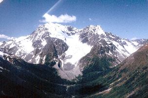
Hard rock miners remember British Columbia's Bridge River Valley for the rich quartz gold mines, with Bralorne and Pioneer being the most notable. Construction workers know the Bridge River as the site of BC's first giant hydroelectric development. Summer adventurers visit the Bridge River Valley for its fishing, hunting, rockhounding and rugged mountain beauty. Snowmobiling on the alpine glaciers draws the winter enthusiasts. I remember it for all those reasons. Above all, I remember it as a great place to grow up. I go back in the summers, to take part in the Bridge River Valley Reunion, this year scheduled for July 31st to August 2nd 2009. On the chance that you are interested in joining the festivities, let me guide you to the communities where I mis-spent my teenage years.
While the valley is also accessible from Shalalth, over Mission Mountain, and from Pemberton, via the Hurley Road, the surest way in is from Lillooet. The Old Mill Plaza shopping centre, on the northern outskirts of Lillooet, is the starting point for a backroad adventure to Bridge River Gold. Bridge River Road (Highway 40) winds north along the west bank of BC's Fraser River for six kilometres before crossing the Bridge River gorge near its mouth. If you travel through here in the fall, you may notice that the confluence of the Bridge and Fraser rivers is a favored First Nations salmon fishing site. After crossing the Bridge River, the road leaves the Fraser and climbs steadily northwest until it reaches the narrow benches high above the even narrower Bridge River canyon. Signs marked "Extreme dust -- use headlights" should be ample warning. Logging trucks use this road and driving "blind" can mean a very short trip -- straight down.
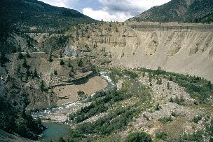
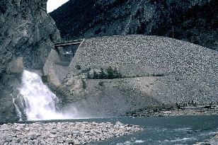
Approximately 30 kilometres from Lillooet, the Bridge River cuts a wide bend around a rock outcropping, creating a deep Horseshoe Canyon. If you are looking for a break, there is room to enjoy the view near the east end of the horseshoe. Beyond Horseshoe Canyon, the Bridge River Road descends to the mouth of the Yalakom River. When we first moved into the valley in the mid-1950s, this was Moha, the site of a few homes and a restaurant. The Chinese restaurant closed nearly half a century ago, and placer miners have chewed up the river bottom. But rockhounds still find the occasional jade pebble in the river gravel. Seventeen kilometres upstream from the Yalakom, the massive earth-fill Terzaghi Dam comes into view. A gravel road crosses the crest of the 55-metre-high, 365-metre-wide dam and leads over Mission Mountain to Shalalth and Seton Portage. Two four-kilometre-long tunnels carry the Bridge River through Mission Mountain to the turbines at Shalalth.
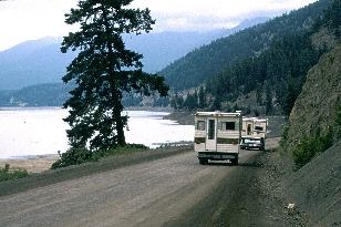
The vast hydroelectric potential of the Bridge River was first recognized in 1912. Work began in 1927, and by 1960 dams were completed at Lajoie, near Gold Bridge, and at the foot of Mission Mountain. They built powerhouses at Lajoie, Shalalth and Lillooet, using the waters of the Bridge River three times to generate 500 megawatts of electricity. In the process, they created two new lakes. Lake Downtown, behind Lajoie Dam, is 26 km long. Carpenter Lake, behind Terzaghi Dam, stretches 55 km to Gold Bridge. In the summer, fishermen troll the lakes for kokanee, rainbow trout and Dolly Varden char. The road into the Bridge River Valley continues west along the north shore of Carpenter Lake, passing the Bighorn Creek recreation site and side roads to Marshall Lakea and Tyaughton Lake (locally known as "Tyax"). If you are looking for a break from the dust, a small recreation site near the mouth of Gun Creek could serve as a place to relax and try a little stream fishing. The mining community of Minto was also once near here. It began in 1933 and became the third largest gold mine in the valley, after Pioneer and Bralorne. The vein petered out a few years later and Minto City declined. The government briefly revived Minto in 1942 as a centre for Japanese displaced from the coast after Pearl Harbor.
Gun Creek flooded in 1950, inundating the town. By 1960, salvagers had removed all of Minto's buildings prior to the flooding of Carpenter Lake reservoir. A bridge across the Bridge River at Gold Bridge (try saying that fast), approximately 100 km from Lillooet, serves as a landmark for a major junction. Straight ahead and to the left at the crest of the first short hill is the start of the Hurley River Road to Pemberton. Keep straight ahead and to the right at the crest and the Lajoie Dam looms ahead, followed by Lajoie (Little Gun) Lake and Gun Lake. The road to the left crosses the Bridge River, just downstream from the confluence of the Bridge and Hurley rivers, and leads into the community of Gold Bridge. During the peak of mining activity, Gold Bridge had a hotel, bakery, newspaper and a few other amenities not discussed in polite company. Although the mines have closed, Gold Bridge is still the valley commercial centre, with accommodations, supplies and fuel. Beyond Gold Bridge, the switchback gravel road climbs steeply. It passes the tiny settlement of Brexton and reaches Bralorne about 10 kilometres later.
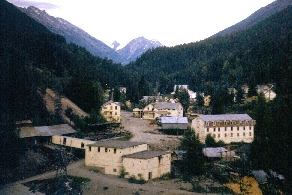
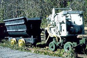
Bralorne and Pioneer produced four million troy ounces of gold before shutting down in the early 1970s. Although rumors occasionally surface about reopening the mines, Bralorne relies on logging and the attractions of the Coast Mountains for its life. The narrow road continues through Bralorne, past the many refurbished homes, the playing field and the museum. The Bralorne Pioneer Museum is located in what was once the "Industrial Education" shop. Here I first learned the finer points of metalwork and woodwork you may find my photo in a few of the school yearbooks. Little else is left of the High School that once housed 125 students. Beyond Bralorne, the road winds through the old Bradian townsite. At Bradian, several rows of once neat homes stand among the weeds waiting for the miners to return or a heavy winter snowfall to bring them crashing to the ground. It's another couple of kilometres to the Pioneer Mine mill, once a major gold producer and now a jumbled wreckage of corrugated steel and timber. Pioneer Mine was my home from 1955 to 1961. I lived in the townsites that have reverted to nature. I delivered the Vancouver Province newspaper to family homes and the miners in the bunkhouses. I spent my school summer holidays working in the sawmill or the mine mill that lies in ruins. I also spent many pleasant days hiking in the nearby mountains, fishing in the streams and following the old mining trails up Cadwallader Creek to McGillivray Pass.
Despite the man-made disruptions of hydroelectric dams and logging, the Bridge River Valley still has many attractions. Gold brought the people into the valley. Gold may attract the miners back. Today the gold of a sunrise on a quiet lake or a sunset on glacial ridge is attraction enough for many visitors. Copyright
© 1999-2009 Murphy O. Shewchuk Be sure to read other articles by Murphy Shewchuk in the BC Adventure Network |