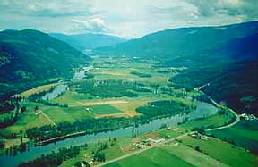
British
Columbia's beautiful Shuswap Lake area has been enjoyed by visitors
for years. Many years ago the Shuswap Indians, for whom the lake was
named, travelled the waterways reaping the benefits of the large fish
runs.
Shuswap
Lake resembles a rough 'H' in shape and is made up of four arms, the
Shuswap Lake Main Area, the Salmon Arm, Mara Lake, Anstey Arm and Seymour
Arm. This unusual pattern is caused by several intersecting valleys
formed by the movement of ancient glaciers in the Shuswap Highlands.
The surrounding area is largely made up of metamorphic rock where rockhounds
will often find blue-gray and banded agate, crystalline geodes and amethyst.
Forest cover is greatly affected by the diverse moisture patterns so
tree species vary from cedar, hemlock, spruce, white pine and Douglas
fir to poplar, birch and ponderosa pine. Living within the forest is
a wide variety of wildlife such as the mule deer, porcupine, black bear,
bighorn sheep, and caribou. Insects are common, making for an abundant
and varied bird population. There are sixteen species of fish in the
lake including kokanee, lake trout, Dolly Varden and burbot, all of
which are popular sport fish.
LOCATION
The
Trans-Canada Highway runs near the southern shore of Shuswap Lake
providing easy access to the area in which the parks are located.
1.
Turn off of the highway at Squilax, near Chase, to find these parks:
Roderick Haig-Brown (5 km from the highway), Shuswap Lake Park (19
km) and Silver Beach (60 km).
2.
To locate Sunnybrae Provincial Park (6 km from Tappen) and Herald
Provincial Park (13 km), take the road that begins at Tappen, near
Salmon Arm.. The Mara Provincial Park is located at the south end
of its namesake lake on Route 97A, 12 km from Sicamous.
Information & Services
If you would like to have your business listed, please Click Here.
PARK
INFORMATION
Main
Arm
Cinnemousun
Narrows Provincial Park: This park is located where all four of
the lakes arms meet and is one of the most popular stopping areas
for visitors. The north side of the park is rather undeveloped, the
south side is where the camping area is located. Beautiful beaches,
shelters and a marine sani-station are found here. A 1.5 km trail
leads the visitor to a viewpoint overlooking the lake.
Roderick
Haig-Brown Provincial Park: This park is known for its massive
sockeye salmon run where 1.5 million fish crowd into just a few
hundred acres of lake bed. Trails are located near the Adams River
for viewing of the life and death spawning saga.
Shuswap
Lake Provincial Park: The Shuswap Lake Provincial Park is located
on the north shore of the Main Arm of the lake. There are many day
and overnight facilities provided for the visitor. The 272 site
campground has a sani-station nearby. A beach, play areas and boat
launch are found near the campground. Two kilometres from shore
is Copper Island where there is a hiking trail that leads to the
islands highest point giving the visitor a wonderful view of the
lake and area. The forest cover once consisted mainly of Douglas
fir and ponderosa pine but due to forest fires and logging most
of the larger growth is gone. A thick second-growth forest of black
cottonwood, white birch, aspen, Douglas fir and western red cedar
can be seen here today.
Seymour
Arm:
Albas:
This beautiful area is located at the mouth of Blueberry Creek. There
is a developed campground south of Blueberry Creek and an undeveloped
site near the mouth of Celesta Creek. A trail leads the nature enthusiast
through a forest of hemlock and cedar, past a series of waterfalls
and remnants of the early logging days.
Silver
Beach Provincial Park: This beautiful area is located at the
head of Seymour Arm. Vehicle access is good and interesting scenic
attractions are found nearby in the forest of Douglas fir and aspen
including the site of old Seymour City.
Two
Mile Creek: This camping area is the first one on the Seymour
Arm. The forest of Douglas fir, hemlock and birch is home to abundant
animal and birdlife.
Anstey
Arm:
Anstey
Beach: This secluded camping area is nestled into a forest of
large cedars and cottonwoods at the mouth of the Anstey River. The
trail leading to Hunakwa Lake is a nature lovers paradise.
Anstey
View: This spectacular viewpoint is found in a forest of Douglas
fir, western white pine and birch.
Four
Mile Creek: On the east side of Anstey Arm is the Four Mile
Creek campground. A meandering creek, small bay and forest of cedar
and hemlock create a majestic setting.
Salmon
Arm:
Herald
Provincial Park: This park is found on the site of the Herald
homestead, a family of pioneers who lived in the Shuswap region and
farmed the land the is now the park. A picnic area, sandy beach and
boat launch ramp are located near the campground. A trail leads through
the forest to Margerat Falls.
Marble
Point: This camping area is located in the forest of cedar and
hemlock. Marble outcroppings and an abandoned mine shaft are points
of interest in the area.
Sunnybrae
Provincial Park: This picknicking, swimming and sunbathing site
is on the northwest shore of Salmon Arm. Bastion Mountain is to
the northwest and across the lake are the Larch Hills.
Mara
Lake:
Mara
Provincial Park: Here on the east side of Mara Lake visitors enjoy
a beautiful beach, picnic ground and boat launching ramp. To the east
is Hunters Range, where 2200 metre Mount Mara is located, and to the
west are the Larch Hills.
as
cross-country skiing and snowshoeing trails during the winter months.

 British
Columbia's beautiful Shuswap Lake area has been enjoyed by visitors
for years. Many years ago the Shuswap Indians, for whom the lake was
named, travelled the waterways reaping the benefits of the large fish
runs.
British
Columbia's beautiful Shuswap Lake area has been enjoyed by visitors
for years. Many years ago the Shuswap Indians, for whom the lake was
named, travelled the waterways reaping the benefits of the large fish
runs. 