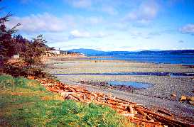
After
leaving Campbell River
and heading North to Port
Hardy and Bear Cove the highway narrows through the lush inland forests.
Seymour Narrows and Ripple Rock Rest Area are located 11 km (7 miles)
north of Campbell River. Ripple Rock was once below the water's surface
and caused over 20 shipwrecks. In 1958, it was finally blown up in one
of histories largest non-atomic blasts in history.
Continuing
north there are many good
fishing lakes such as Roberts Lake. The road to Sayward-Kelsey Bay
is located 64 km (40 miles) north of Campbell River which winds into the
Salmon Valley where the Salmon River emptied into Johnstone Strait at
Kelsey Bay.
Sayward
& Kelsey Bay:
First settled in 1890, this area is the centre of a rich logging and farming
industry. Kelsey Bay once served as the southern terminal for the BC Ferries
Inside Passage to Prince Rupert.
Travelling
further north along Highway 19, you will pass through grand
forests, stunning mountains and streams. Access to Schoen Lake, Schoen
Lake Provincial Park and Vancouver Island's largest watershed is via a
logging road 93 km (58 miles) north of Campbell River.
Schoen
Lake and Provincial Park:
Possibly one of the most scenic lakes on the island, Schoen Lake provides
excellent hiking, canoeing and wildlife viewing oppurtunities. Downhill
and nordic skiing is possible at the Mt.Cain Alpine Park.
Further
along Hwy 19 is Woss Junction, a small logging town with an antique steam
locomotive and, during the summer, a five-hour logging railway run through
the Nimpkish Valley. Other interesting spots include the Little Hustan
Cave Regional Park, Zabellos, a base for trips around the Nootka Sound,
and Fair Harbour.
Back to
Hwy 19 by Nimpkish Lake and on to Beaver Cove Turnoff where you may visit
Telegraph Cove.
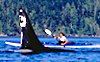
Telegraph
Cove:
First established because of the telegraph line then later as a sawmill
community, Telegraph
Cove is located 187 km (116 miles) north of Campbell River and 15
km (9 miles) southeast of Highway 19. This picturesque village stands
on stilts in the water and now serves as a base for whale-watching tours
in the Johnstone Straits and Robson Bight. It has been a B.C. Ecological
reserve for the protection of orca habitat since 1982.
Other
stops further north include Port McNeill, Alert Bay on Cormorant Island
and Sointula on Malcolm Island.
Port
McNeill:
Primarily a logging town, Port McNeill is 194 km (120 miles) north of
Campbell River, east of Highway 19. The area provides excellent sports
fishing and whale
watching tours.
Alert
Bay-Sointula:
From Port McNeill car and passenger ferries run to Alert Bay on Cormorant
Island and to Sointula on Malcolm Island. Alert Bay, with a large native
population is a good place to shop for native arts and crafts, visit the
long house, cultural centre, tallest totem pole and view potlatch masks
on display. Sointula, once a Finnish cooperative community, is now a fishing
village.
Port
Alice:
58 km (36 miles) off of Hwy 19 is Port Alice on Neroutsos Inlet. This
is an excellent base from which to explore the inlets of Quatsino Sound.
The Sound and nearby lakes provide excellent angling opportunities.
Further still
along the last leg of the Island Highway to Port Hardy another side trip
is to Holberg Inlet and Coal Harbour which was an Air Base during WW II.
Port
Hardy:
The waters around Port Hardy provide excellent angling opportunities for
Chinook salmon, halibut and ling cod. Port Hardy is a scenic spot at the
northern end of the island.
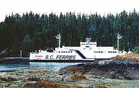
Prince
Rupert Ferry:
The terminus for BC
Ferries traveling the 490 km (304 miles) through the Inside Passage
to Prince Rupert is located in Bear Cove. Reservations are necessary for
this 15 hour journey.
To
Cape Scott:
Cape Scott, at the extreme northwest end of Vancouver Island is accessed
via the Cape Scott Trail
or by kayak
from the Queen Charlotte Strait (from the east) or the Pacific (from the
west).
The
many remote areas of Vancouver Island are best accessed by roads such
as Hwy 28 to Gold River
and Tahsis, Hwy 4 from
Parksville through Port Alberni onto Ucluelet and Tofino and Hwy 18 which
is north of Duncan to Lake Cowichan, Bamfield and the West Coast Trail.
The following BC Adventure members would like to serve you:
Spirit of the West Adventures: We offer sea kayaking tours to the Johnstone Strait & the largest pods of killer whales on the BC coast – Desolation Sound, Quadra Island, & Campbell River - & guided excursions to explore ancient native villages. Set a course for a one of a kind wilderness... more

 After
leaving
After
leaving 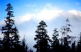 Further
along Hwy 19 is Woss Junction, a small logging town with an antique steam
locomotive and, during the summer, a five-hour logging railway run through
the Nimpkish Valley. Other interesting spots include the Little Hustan
Cave Regional Park, Zabellos, a base for trips around the Nootka Sound,
and Fair Harbour.
Further
along Hwy 19 is Woss Junction, a small logging town with an antique steam
locomotive and, during the summer, a five-hour logging railway run through
the Nimpkish Valley. Other interesting spots include the Little Hustan
Cave Regional Park, Zabellos, a base for trips around the Nootka Sound,
and Fair Harbour.
 Prince
Rupert Ferry:
Prince
Rupert Ferry: