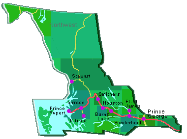
Burns
Lake | Fort St.
James | Fraser Lake | Granisle
Haida
Gwaii | Hazelton
Highway37:
Iskut, Telegraph Creek, Dease Lake
Houston |
Kitimat
| McBride | Oona River
| Prince George
Prince Rupert |
Smithers
Stewart |
Telkwa | Terrace | Vanderhoof
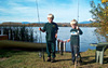
BURNS LAKE
At the centre of an area known as the Lakes District, the
community of Burns Lake serves as the launch point for wilderness
adventures of all kinds. Some of the best fishing in BC can be found
in the area's many lakes. To the south, Tweedsmuir Park beckons
hikers and campers. But, there's more to see and do: nature trails,
a golf course, curling, skating rink, tennis courts, mountain biking,
horseback riding, swimming, water sports, hunting, and boating.
Burns Lake is located 230 km (142 mi) west of Prince George on Hwy
16.
FORT
ST. JAMES
Just 60 km (37 mi.) north of Vanderhoof is Fort St. James.
First established as a fur trading post in 1806, it is now a centre
for the forest industry. The re-created Hudson's Bay trading post
at the National Historic Site has reenactments of fur trading life
that is surely the highlight of a visit to Fort St. James. The area
also contains one of the oldest churches in British Columbia. Ft.
St. James offers a golf course, hiking trails, ski hill, public
beaches, fishing and hunting lodges, houseboats, hiking, biking,
and camping.
FRASER
LAKE
Set along the shores of Fraser Lake and a fly rod's cast
from hundreds of other lakes, is the village of Fraser Lake. There
are lakes in every direction which have lodges and resorts popular,
not only for fishing, but for family vacations. Canoeists enjoy
the many rivers while hikers, sightseers and mountain bikers can
enjoy the many backwoods trails. There's a golf course too, so bring
along your clubs. There are a number of private and provincial campsites
in the area with many lodges and resorts on the surrounding lakes.
Fraser Lake is located on Hwy 16, 160 km (99 mi) west of Prince
George
GRANISLE
The village of Granisle is built upon the shores of Babine
Lake; the longest natural lake in British Columbia. First built
to support the copper mines in the 1960's, it now depends on its
location and recreational appeal to attract residents and visitors.
Babine Lake offers prime fishing and boating. The surrounding forested
The village of Granisle is built upon the shores of Babine Lake;
the longest natural lake in British area provides plenty of opportunity
for hiking, hunting, camping and any number of outdoor adventures.
Just west of Burns Lake, you turn north off Highway 16 (Yellowhead)
at Topley. Granisle is 50 km (31 mi) from Topley.
HAIDA
GWAII (QUEEN CHARLOTTE ISLANDS)
Haidi Gwaii is an archipelago of more than 150 islands.
It has gained a reputation for outstanding natural beauty and a
remarkable First Nations culture. This area can provide something
of interest to everyone; history, archeology, fishing, boating,
hiking, biking and more. The four main towns (Massett, Queen Charlotte
City, Sandspit, Skidegate) and numerous communities on the island
all have something unique to offer. To reach the islands, you can
travel from Prince Rupert by air or ferry. The trip by air is about
45 minutes; the ferry crossing takes about six hours. Direct air
service from Vancouver is also available
HAZELTON
Located close to the junction of the Bulkley and Skeena
Rivers, the original Hazelton settlement, built on the flats where
the hazel nut bushes grew thickly, began as a riverboat stop. South
Hazelton or "South Town" and New Hazelton or "New Town", sprang
up with the building of the Grand Trunk Pacific Railway in the early
1900's. The communities are all either on or very close to Highway
16, 124 km (77mi) east of Terrace. Recreational activities: fishing,
hiking, camping, wildlife viewing, trail rides, local arena, ball
diamonds, historical, wildlife and natural history tours
HIGHWAY
37: ISKUT, TELEGRAPH CREEK, DEASE LAKE
Iskut, Telegraph Creek and Dease Lake are located along
Highway 37, often referred to as the Stewart-Cassiar Highway. It
links the Yellowhead 16 with the Alaska Highway west of Watson Lake.
The 733 km (454 mi.) route is slightly shorter than the comparable
route on the Alaska Highway. On this route you will see some of
the most inspiring beauty and abundant wildlife on this continent.
HOUSTON
Halfway between Prince George and Prince Rupert, Houston
is both a wilderness and an industrial hub. Forestry and mineral
explorations have contributed to the area's prosperity but recreation
and fishing in the area's rivers and lakes are bringing more people
to Houston every year. The lakes, rivers and forest entice those
interested in backpacking, camping, canoeing, photography and wildlife
viewing. Visitors will also find 2 golf courses, a swimming pool,
curling & skating rink, and cross country ski trails. Houston is
located 80 km (50 mi) west of Burns Lake on Hwy 16.
KITIMAT
For those interested in nature and industry, Kitimat is
an excellent choice. The community enjoys a beautiful natural setting
and is also home to some of the most advanced industrial technology
in North America. Kitimat offers racquet courts, a gym, soccer and
baseball fields, skating rinks, aquatic centre, golf course, established
hiking trails, heli-hiking tours, fishing, swimming, camping, scuba
diving, water-skiing, wildlife viewing, charter fishing companies.
Kitimat is 60 km (38 mi.) south of Terrace on Highway 37.
MCBRIDE
McBride, the first B.C. community on the Yellowhead Highway,
has a history tied to railroads and forestry. The Robson Valley's
exceptional scenery and recreation opportunities draw back packers,
anglers and white water enthusiasts. McBride offers a golf course,
recreation centre, curling/skating/roller skating rink, ski trails,
hiking trails, and heli-skiing. There is camping at the nearby Konneman
Regional Park, and there are motels/lodges available in and near
town. The community is right on the main Highway 16 (Yellowhead).
It is 220 km (136 mi.) east of Prince George and 65km (40 mi.) north
of Tete Jaune Cache.
OONA
RIVER This small northern coastal community is on Porcher Island
about 42 km (26 mi ) south of the port of Prince Rupert.
PRINCE
GEORGE
Prince George is the largest service centre for the northern
part of British Columbia; perfectly situated at the crossroads of
two major highways and two railways. Once a fur trading fort, Prince
George now has all the modern amenities amidst a sea of natural
attractions that entice visitors from around the world. Recreation
Facilities & Activities: golf courses, ice & curling rinks, tennis
courts, pools, parks, ball diamonds, trails, forest tours, hiking,
biking, fishing, boating, swimming, kayaking, waterskiing, camping,
and hunting. Prince George is located at the crossroads of Highways
16 and 97, 786 km (487 mi) north of Vancouver, and 721 km (447 mi)
east of Prince Rupert.
PRINCE
RUPERT
Where the Yellowhead Highway 16 meets the Pacific, you'll
find Prince Rupert, and en route you will drive along one of the
most scenic stretches of highway in the world. Prince Rupert is
home to Canada's deepest ice-free harbour and acts as a base for
those wanting to take advantages of the adventures waiting just
off the coast or on the mainland; whalewatching, sea kayaking or
fishing, hunting, hiking and backcountry expeditions are all close
at hand. It is a hub for ferry, rail and air traffic as well as
being the western end of the Yellowhead Highway 16. There are regular
ferry sailing from Prince Rupert to Alaska, the Queen Charlotte
Islands and Vancouver Island.
SMITHERS
Smithers is set in the Bulkley Valley, against a backdrop
of towering mountains. Numerous lakes, rivers and waterfalls provide
outdoor adventures. Area lodges cater to those who are keen for
fishing, wildlife watching, canoeing or even photo safaris. Local
golf courses, a swimming pool, curling & skating rinks, a fitness
trail, picnic sites, cross country & downhill skiing, horseback
riding, river rafting, snowmobiling and waterskiing are just a few
of the things to keen you busy. Smithers is located on Highway 16,
370 km (229 mi) west of Prince George and 68 km (42 mi) east of
the Hazeltons.
STEWART
Stewart sits at the head of the Portland Canal, a 90 mile long
ocean fjord which forms a natural boundary between Canada and Alaska.
Towering peaks, chilling glacier scenes and unparalleled bear-watching
make it a must-see. The townsite is very interesting with many of
the buildings dating from 1910 when 10,000 people lived there. Stewart
is on Highway 37A, north off Highway 16 at Kitwanga, Greyhound Bus
Lines travels the highway north and south. The 61 km (38 mile) road
joining Stewart with the Cassiar Highway is one of the most spectacular
in the North.
TELKWA
Located at the junction of the Telkwa and Bulkley Rivers,
Telkwa is also known for its many possibilities for the outdoor
enthusiast. Hiking, wildlife viewing, fishing and heli-skiing are
just some of the activities to be experienced in the area. Telkwa
lies on the major Highway 16 just 10 km (6 mi) east of Smithers.
Nearby Tyhee Lake Provincial Park offers camping, picnicking and
boating.
TERRACE
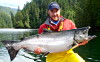
Fishing, adventures, lava beds and a chance to see the rare
Kermodi bear are but a few of the enticements to visit Terrace.
Anglers migrate to Terrace to challenge the legendary steelhead
and spring salmon of the Skeena River. There are also a multitude
of opportunities for those who enjoy swimming, boating, camping
and hiking. The city of Terrace is easily accessed from all directions.
Terrace is on air, rail and bus routes while being on the Yellowhead
Highway 16, 140 km (87 mi) east of Prince Rupert and 581 km (361
mi) west of Prince George
VANDERHOOF
Located in the centre of British Columbia, Vanderhoof is
a pleasant agricultural and forestry based community with nearby
opportunities for outdoor adventures. You will enjoy the golf course,
ski trails, riding arena, curing and skating rink, bowling alley,
tennis courts, fishing, boating, canoeing, waterskiing, hunting,
and camping. Vanderhoof is located on the Nechako River 100 km (62
mi) west of Prince George on Highway 16.
|