Vancouver,
part of the fabulous west coast, offers a few very good day trips, they
include the Vancouver Harbour, the Fraser River Estuary, English Bay
and False Creek. For experienced and adventurous kayakers there's the
crossing of Georgia Strait, from Tsawwassen to Galiano, a 19.3 km (12
mi.) paddle, the longer one is from Vancouver to Nanaimo.
Minutes from down town Vancouver there are several excellent weekend
kayaking trips you can experience.
Indian Arm a classic coastal inlet is only minutes from the hustle and
bustle of the city. You'll enjoy great B.C. mountain scenery as well
as waterfalls and a few little islands. There can be plenty of water
traffic in and around Deep Cove, Belcarra and Bedwell Bay. From Burrard
Inlet to the Buntzen Power Plant you will find small beach communities,
but after you leave Coldwell Beach touches of civilization are behind
you. Continuing up the arm takes you by Silver Falls, Croker Island
and the highlight of this trip, the multi-tiered Granite Falls. At high
tide you can paddle up Indian River to enjoy some great fishing.
Access: Launch at Deep Cove, only 9 km (5.6 mi.) east of Second Narrows
Bridge in North Vancouver. Another place to launch is at Belcarra Bay,
28 km (17 mi.) east of Vancouver. Take Hastings Street and Barnet Highway
to Port Moody, from here you just follow the signs to Belcarra.
Trip time: Two to four days.
Difficulty: This area is great for beginners and families as the waters
are protected and usually calm. There can be a lot of small boat traffic,
so watch for them and the boat waves.
Season: Year round, but best from March to November, when it is less
congested and more scenic.
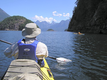
A kayak trip on Howe
Sound means striking mountain scenery, a bird sanctuary, a seal
colony, good hiking, good fishing and all close to Vancouver. The best
sea kayaking in Howe Sound is along Gambier and Anvil Islands, that
are in the northern half. There's less traffic and more camp sites in
this region. The launch from Porteau Cove means crossing the often choppy
Montagu Channel, while the launch at Port Mellon is on the protected
Thornborough Channel.
Access: On the east side of Howe Sound, you can launch at Porteau Cove,
a 26 km (16 mi.) drive north of Horseshoe Bay ferry terminal on Highway
99. If you wish to launch at Port Mellon, take the ferry from Horseshoe
Bay to Langdale on the Sunshine Coast. On departing the ferry, turn
right for 11 km (6.8 mi.) to Port Mellon.
Trip time: Two to four days.
Difficulty: Good family and beginner sea kayaking area. Stay away from
Queen Charlotte Channel, because of the water traffic and strong winds
blowing south from the mountains can whip up dangerous waters. Always
be very careful of traffic in parts of the sound, as Horseshoe is the
ferry terminus for both Vancouver Island and the Sunshine Coast.
Season: March to November, when it's less crowded and more scenic.
The
Sunshine Coast refers to an area stretching along the northeast shores
of the Strait of Georgia from Gibsons
to Powell River
and Desolation Sound. As the Powell River region and the Sechelt Peninsula
are separated by Jervis Inlet (and connected by BC Ferries), Powell
River is known as the 'Upper'
Sunshine Coast and the Sechelt Peninsula is known as the 'Lower'
Sunshine Coast.
The
following information refers to Sechelt and Narrows Inlet. For information
on other areas of the Sunshine Coast, please refer to Powell
River, Desolation Sound, Lund,
Jerivs Inlet, Sechelt
or Gibsons.
Sechelt
and Narrows Inlet:
This
area on the Sunshine Coast of B.C. is ideal for kayaking beginners who
want to experience a fjord trip. This region offers abundant shellfish
(oyster, crabs and clams), easily reached wilderness, tidal rapids and
gorges. Leave all the urban trappings behind and head to Tuwanck Point.
The beaches at Tuwanck Point, Skaiakos Point, Nine Mile Point, Halfway
Beach, Kunechin Point and Islets are all designated provincial government
recreational areas, so camping is allowed. The mountain peaks that tower
over Sechelt Inlet can best be seen from Kunechin Islets and Point.
The narrowest of all coastal inlets is Narrows Inlet and the most scenic
spots along this trek is Tzonnie Narrows. It is best to paddle this
area with favorable tide.
Access:
To reach the Sunshine Coast from Vancouver take the Horseshoe Bay Ferry
to Langdale and from Vancouver Island, the ferry runs from Comox to
Powell River. Sechelt is 28 km (17.4 mi.) north of langdale on Highway
101. From Sechelt, head to Porpoise Bay Provincial Park, the launch
site is past the park entrance, just south of Tuwanck Point. The other
launch point is at Egmont, at the northern end of Sechelt Inlet. This
launch,, because of the Sechelt Rapids has to be traversed at slack
tide and with extreme caution.
Time
Travel: From three to six days.
Difficulty:
The Sechelt and Narrows Inlets are excellent kayaking for beginners
and families.
Season:
Because your can avoid weekend water traffic, kayaking here is good
from April to October
Located on the Sunshine
Coast, between Powell
River and the Sechelt
Peninsula, Jervis Inlet carves deep into the Coast Mountains of
British Columbia. The snow capped mountains, the cascading waterfalls,
the cliffs, the Indian pictographs, the glaciers and the wildlife makes
this one of the best sea kayaking trips in B.C.
To experience the best of Jervis Inlet, is to experience either the
beginning or the end. At the mouth of Jervis, the outer islands provide
interesting channels and bays and lagoons to poke around by sea kayak.
These islands include Nelson Island, Hardy Islands and the smaller islands
and islets of the area. A little further inland, Hotham Sound carves
a deep tangent into the steep, glaciated mountains. With very warm waters,
almost no wind, and the obvious draw of Freil Falls splashing down the
mountainside from far above, Hotham Sound provides a unique sea kayaking
experience.
Heading
deeper into Jervis Inlet is, perhaps, best done with the help of a motor
vessel. Jervis Inlet itself can be a long, and often windy, paddling
experience. However, once through Jervis Inlet, you arrive at Prince
of Wales Reach, where the shoreline mountains seem to go straight up.
Queens Reach is next, and finally you reach the cream of Pacific Coast
inlets, Princess Louisa Inlet. You are now surrounded by superb scenery
and quiet. At the head of the inlet is Chatterbox Falls and Princess
Louisa Marine Park, a very popular spot with boaters in the summer.
Access: Access to Jervis Inlet is either from the Sechelt Peninsula
or north of Powell
River. On the Sechelt Peninsula side, the three main launch sites
are from Egmont, Earl's Cove or Irvines Landing. On the Powell River
side, Saltery Bay acts as the main put-in for Jervis Inlet trips. All
sites mentioned have advantages and disadvantages depending on where
exactly paddlers are looking to go. It is recommended to contact a local
sea kayak company to gain more specific information. Note that Saltery
Bay and Egmont are connected by BC Ferries.
Trip
Time: Exploring the outer islands and Hotham Sound is best done in a
3-5 day trip. However, day or overnight trips are possible from any
of the launch sites.
If Princess Lousia Inlet is the destination, it may be worthwhile to
look into a motor vessel transport from Egmont. Trip duration in this
case may be 3-6 days, depending on whether or not the motor vessel transport
is for both ways or just one way. Otherwise, if paddling up Jervis,
consider taking six to twelve days, depending on how far inland you
go.
Difficulty:
Experience is necessary. The inlet is long and narrow, so winds funnel
up and down the length, and the rockwall coastline makes for difficult
landings.
Season:
Anytime from April to October. Princess Louisa Inlet gets very busy
in July and August, so you'll find May, June and September your best
times.
The
scenery and warm protected waters teeming with marine wildlife make
Desolation Sound one of the best sea kayaking areas on the
B.C. coast.
Visitors
to this area enjoy meandering through the many inlets, channels, coves
and bays as they explore by sea kayak. The towering mountains of the
Coast Mountain Range create a dramatic backdrop, and the rich sunsets
towards Vancouver Island light-up evening skies.
With
water temperatures reaching as high as 26C (79F), swimming is a popular
option to the Desolation Sound experience. However, perhaps even more
enticing than swimming is the opportunity for up-and-close experiences
with the area's rich and colourful intertidal marine life. Snorkeling
in Desolation Sound is wonderful. With Giant Sunflower Stars, Red Sea
Urchins, prickly-looking Sea Cucumbers, spiny Rockfish, and so much
more, snorkeling in Desolation is a highly recommended activity.
Desolation
Sound Marine Provincial Park is comprised of 5,666 hectares (14,000
acres) of forested upland and 2,570 hectares (6,350 acres) of foreshore
and is one of British Columbia's largest marine parks. This, in combination
with the areas adjacent to Desolation Sound, makes for one extremely
large ocean playground. For many kayakers a trip to Desolation Sound
includes paddling into the majestic mountains of the Redonda Islands
and into Toba Inlet. For other more laid-back paddlers, paddling Desolation
means including some downtime on the sandy beaches of Savary Island
or meandering through the ragged islands of the Copeland
Islands Marine Park, just off of Lund.
For those with a little less time, the "backside" of Desolation
Sound Marine Park includes Okeover, Malaspina, Lancelot and Theodosia
Inlets, all beautiful and sheltered areas to explore by sea kayak. And,
yet another option to include as part of the Desolation Sound experience
is Cortes Island, its secluded lagoons and beautiful marine parks.
Access:
Located 30km's north of Powell
River, on the Sunshine Coast, access to Desolation Sound is often
through Powell River and then on to staging areas north of Powell
River in either Lund
or Okeover Inlet. Powell
River is accessible by ferry from Vancouver (Horseshoe
Bay) and from Vancouver Island (Comox).
Another option to access Desolation Sound is via ferry from Campbell
River to Quadra Island
and then on to Cortes Island. From Cortes, launch sites are located
at either Squirrel Cove or Cortes Bay.
Trip
Time: Day trips into Desolation Sound Marine Park can be experienced
if launching from Okeover Inlet. Otherwise, most paddlers experience
Desolation Sound over trips ranging from 3-6 days. For those seeking
to fully experience Desolation Sound and the surrounding destinations,
at least a week is optimal, if not longer.
Difficulty:
Waters here are mostly protected and rarely rough, except for Toba Inlet.
Good family kayaking.
Season:
Anytime from March to October, like many other areas, it's busiest from
mid-June to mid-September.
This region is very distinct with isolated settlements. The scenery
along Knight Inlet is hard to surpass, no matter where you travel. Both
petroglyphs and pictographs can be found here, but the seas is very
challenging. The inlet and channels are long and narrow, water can be
wild and the tidal current and winds are definitely factors. Knight
Inlet is for experienced, adventurous kayakers and suitable for one-way
trips only. It is best to fly in and paddle out.
Access: Drive to Kelsey Bay, north of Nanaimo on Highway 19, or drive
further north to Port McNeill or Beaver Cove, where charter plane arrangements
can be made. This will dictate your departure point.
Trip Time: Anywhere from eight to twelve days, one way only.
Difficulty: This paddle is for experienced sea kayakers, who are looking
for adventure.
Season: From March to October. Time you trip for the oolichan harvest
in March and early April.
Located in Barkley
Sound, this archipelago of over 100 small but rocky islands is one
of the most popular B.C. areas for sea kayaking. It's great for families
and people that are new to the sport, therefore, can be crowded during
July and August. Access the Broken Groups from Port Alberni by taking the
passenger vessel M.V. Lady Rose directly to the Islands, a trip that
takes three hours. Or you can launch from Toquart Bay which is a five
miles paddle. Once you reach the Broken Group, you can make your way
around the group by paddling from island to island, where you will find
sandy beaches, protected anchorages and an abundance of both birds and
marine wildlife. The Broken Group Islands is part of the Pacific Rim
National Park and has eight designated camping areas where everyone
must camp. Kayaking this area can take anywhere from three to ten days
and can be best enjoyed during the off season.
To reach Clayoquot
Sound, take Highway 4 to Tofino on the west coast of Vancouver Island.
Launch from the public wharf and be on your way to an outstanding sea
kayaking trip. The most popular spot along this coast line is Hot Springs
Cove. It is definitely worth a visit, just to soak in the warm and soothing
springs. From Tofino to Hot Springs Cove you can paddle either side
of Vargas and Flores Islands, depending on your sea kayaking capabilities.
On your way, you will pass Meares Island, take time out to explore it.
Both Vargas and Flores Islands have lovely sandy beaches. To explore
this region it can take from six to twelve days, with beaches everywhere
there is no camping problem.
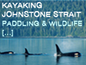
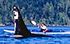
Other great sea kayaking spots off Vancouver Island include Nootka Island,
Cape Scott to Brooks Peninsula, Johnstone Straits including Robson Bight
and Blackfish Sound.
Nootka
Sound:
Paddle
along Nootka Sound either in canoe or kayak. Visit
Crawfish Falls where Kelven Creek enters the Pacific
Ocean. Admire the variety of inter-tidal life
at Bajo Point. Then continue towards Yuquot (Friendly
Cove). Wolves, sea otter, sea lions, black bears,
cougars, and bald eagles can be spotted and viewed
along Nootka Sound. Safety is very important and
only very fit and experienced kayakers and canoers
should attempt this or go with an experience guide.
The
Gulf Islands in the Strait
of Georgia between Vancouver
Island and the B.C. mainland attract kayakers
from all parts of British Columbia, Canada and
the world. This archipelago enjoys a mild, almost
Mediterranean-type climate and is popular with
people who enjoy outdoor recreational activities.
There are more than 200 Gulf Islands, but most
are small, uninhabited without facilities and
ferry service. Only eight islands have permanent
inhabitants, but its Saturna, Saltspring, North
and South Pender, Mayne and Galiano that are well
known and receive most of the visitors.
The mild climate and protected waters, make the
Gulf Islands the perfect kayaking destination.
Kayaking means you can visit the smaller islands
to enjoy the scenery, the tranquillity, and the
marine wildlife. Tidal currents here are usually
harmless, crossings from one island to another
short, and you can always find a landing spot
on a sandy beach. Watch for sudden winds. Narrow
channels and steep shorelines can make winds gusty
and dangerous. The best times to a kayak the Gulf
Islands are mornings and evenings, and the best
seasons are late summer and early fall. Active
Pass and Porlier Pass should be avoided by unexperienced
kayakers because of the strong and hazardous tides.
Saltspring Island:
The name Saltspring comes from the fourteen brine
springs found on the north end of the island.
Saltspring is the largest and most populated of
the Gulf Islands with approximately 8,000 inhabitants.
Its diversity includes mountains, cutthroat streams,
trout and bass lakes and more than 600 km (370
mi.) of roads. Saltspring offers great hiking,
fishing, kayaking, canoeing, beachcombing, and
cycling. Easily reached by ferry from Vancouver
Island and the mainland, sightseeing and enjoying
the lay back life style attracts many visitors.
This is a good starting point for kayaking trips
to the outer islands, but first explore all the
enjoyable kayaking Saltspring offers. The longest
kayak trek is from Fulford Harbour to Musgrave
Landing, which can take up to four hours. Most
of this trip is in calm waters, but be careful
around Isabella Point and at the beginning of
the trip, as ferries from Swartz Bay and Fulford
Harbour create swells. An interesting three hour
cruise is around the Chains Islands in Ganges
Harbour where there is plenty of marine wildlife.
Mink, harbour seals and otters are common, and
the seabirds include gulls, cormorants, diving
ducks and black oyster catchers.
Kayaking from Southey Point or Fernwood Point
easily reaches Wallace Island, a B.C. marine park.
The island has sheltered anchorages, beaches and
grassy campsites. You can camp on the beaches
or fields, but fires are not allowed. Use Wallace
Island as a jumping off spot to tour the Secretary
Islands, Hall, Reid, Norway and Jackscrew islands.
Fulford Harbour to Jackson Rock is a pleasant
paddling area with sandy beaches for quick anchorages
should the winds come up. Jackson Rock, an islet
has clear shallow waters, interesting beaches
and should be visited at low tide.
A cruise around Walker Hook, gives you an opportunity
to look across Trincomali Channel to Galiano Island.
Add mileage to this tour by going to the north
end of Saltspring, paddle to Fernwood and around
Southey Point. Paddlers use this most northerly
tip as a launch point for trips on both sides
of the island and to Idol Island.
A trip along Long Harbour takes you to Scott Point,
a popular bald eagle roost, so make sure your
camera is handy. Across the harbour from Scott
Point are a group of islets and some coves near
the end of Nose Point a great place for a picnic
and swimming. In a period of about two hours,
you can paddle up and down Long Harbour with Prevost
Island for protection from the southeasterly winds.
Ganges Harbour on its own has excellent kayaking
with coves and bays that can easily take up a
weekend of exploring.
Launch your kayak off Erskine Point in Stuart
Channel for the trip to Vesuvius and Booth bays.
Booth Bay is an interesting spot, because of the
narrow inlet gap, it takes on pond-like atmosphere.
Saltspring has several excellent anchorages for
kayaks and other small crafts. Ganges Harbour
has a sheltered government wharf and many protected
anchorages. Long Harbour is a terminus for ferries,
but Prevost Island, with major bays and inlets
offers good anchorages. Temporary protection is
available at Walter Hook, and there is a government
wharf at Fernwood that provides very limited space.
Both Wallace Island and the Secretary Islands
have some good anchorages. Close to a store, motel,
a restaurant and a neighbourhood pub is the government
wharf at Vesuvius and the tiny coves behind Dock
and Parminter points have anchorage. Booth Bay
and Inlet offer protection from winds. Burgoyne
Bay has some good temporary anchorage at the head
of the bay and a small government wharf is near
a booming ground. Private and government docks
are in Musgrave Landing. Fulford a busy community
has government wharves, Beaver Point is exposed
to ferry wash, but behind Russell Island is a
private retreat.
The Pender Islands:
North and South Pender Islands, with a permanent
population of about two thousand, are known for
their beaches and many bays. Unlike the other
islands that ferries serve, the Penders shorelines
are accessible by public right of ways. The islands
are joined by a bridge over a canal between Bedwell
and Browning harbours that they built in 1955.
Like the other Gulf Islands, the Penders are home
to many artists whose studios and galleries exhibit
and sell their art work. A tour of the galleries
is a great way to learn about the Penders and
to take in the sites. Excellent kayaking, canoeing,
hiking and biking make North and South Pender
popular with the recreational crowd.
The area between Port Washington and Wallace Point,
a distance of 8.5 miles, offers interesting kayaking
with numerous coves and islets to explore. The
best part of this trip is between Stanley and
Mouat points, which is only a four mile paddle.
You can travel down the south side of the island
to Boat Nook, but only if the weather is calm.
If you wish to kayak farther down the south side,
keep in mind, there are few places to land along
The Oaks.
Kayaking the northeast side of North Pender can
start from either Colston Cove or Hope Bay and
head to Hamilton Beach. Hope Bay also serves as
a launching spot for trips around Plumper Sound,
across Navy Channel to Mayne Island.
Browning and Bedwell Harbours are both interesting
and fun places to kayak. Start your trip in Browning
Harbour at Hamilton Beach and follow the shoreline
in the harbour and down the south side to Aldridge
Point and Shark Cove. If the tide is right, make
your way into Bedwell Harbour and Medicine Beach.
Stay along the south shore from Medicine Beach
to Peter Cove, an easy trip of 2.5 miles. From
Peter Cove, head across the Bedwell Harbour entrance
to Hay Point on South Pender. Paddle back to Browning
Harbour along the shore of Beaumont Marine Park,
around Ainslie Point and back through the canal.
Bedwell Harbour is busy because nearby Beaumont
Marine Park is popular with all types of boaters.
And in summer there is a Canadian Customs Port
of Entry for sea crafts at Bedwell Harbour.
There's good moorage at Hyashi Cove, located on
the north side of Otter Bay. Moorage can be found
within Beaumont Marine park. Shark Cove has good
anchorage, Browning Harbour has a government wharf
and a marina for moorage. Hope Bay and Port Washington
both have government wharfs.
Galiano:
This long, narrow island is the second largest
of the Gulf Islands and home to a population of
approximately 950, that greatly increases during
the summer and on weekends year round. The sandy
beaches, sheltered harbours, relaxed atmosphere,
art and craft galleries, small resorts, restaurants,
lodges and bed and breakfasts make Galiano an
attractive getaway. It is popular for fishing,
hiking, mountain biking, sailing, scuba diving
and kayaking.
Kayaking Galiano Island means enjoying the offshore
islets, islands and Montague Harbour Park. Montague
Harbour is one of the busiest in the southern
Gulf Islands and the park has a wharf and several
mooring buoys. Many kayakers make Montague Harbour
Park home base for paddling the surrounding area.
There is a group of privately owned islands, including
Parker Island that make for an easy two to three-hour
circle trip. Paddle to Ballingall Islets where
you can see double-crested cormorants and their
unique nests sitting in the tops of the short
Rocky Mountain juniper trees. Prevost Island,
offer protected anchorages and is a three-mile
trip across Trincomali Channel from Montague Harbour
entrance.
A good place to see harbour seals, sea lions,
otters and eagles is at Retreat Cove, where you
can enjoy a leisurely row. Launch your kayak at
Whaler Bay and paddle the protected waters to
Gossip Island, or make a trip around the island
and nearby coves.
Government wharfs are found at Sturdies Bay near
the ferry terminal, at Whaler Bay, at Retreat
Cove, Montague Harbour and North Galiano. Kayaking
in and around the small offshore islands, the
coves and bays on Galiano, is an excellent way
to enjoy this attractive and tranquil part of
B.C.
Mayne:
This island of about 550 permanent residents is
a mixture of old and new. The old dates back to
the 1850, when gold was discovered on the Fraser
River. Many making their way to the gold fields,
stopped On Mayne Island in Miners Bay, because
it was close to the half way point from Victoria
to the mainland. The new are the modern subdivisions
of Village Bay. Beautiful old mansions are next
door to modern contemporary homes, it is an interesting
mixture that gives the island character.
The island has no provincial parks, but lovely
beaches and majestic views of the ocean are inviting.
Kayaking, fishing, hiking, community fairs and
craft sales and theatre performances are all part
of Mayne.
A kayak trip between Village Bay and Dinner Point
is a good shoreline paddle, but be careful of
the wash from ferries travelling this area. In
good weather, many continue kayaking down Navy
Channel to Conconi Reef, Gallagher Bay or even
Piggott Bay.
Horton Bay with a government wharf is sheltered
by Curlew Island, making it a safe spot for youngsters.
Kayaking Robson Channel and the outside edge of
Curlew Island is for more experienced persons,
as there are some tidal currents. Bennett Bay
can be your launching point for trips southeast
to Horton Bay, northwest around Campbell Point
to Campbell Bay and between Mayne and Saturna
Islands.
The mooring facilities at Village and Dinner Bays
offer only temporary anchorage, as they are exposed
to winds and ferry wash. Situated midway through
Active Pass is Miners Bay, a busy community in
summer and a government wharf with limited space.
David Cove offers some safe anchorage. Campbell
and Bennett Bays have temporary anchorage. Horton
Bay has a government wharf with limited space.
On the south side of the island, both Piggott
and Gallagher Bays offer temporary anchorage.
Saturna:
This Gulf Island is the most remote and least
populated, but larger than Mayne or the Penders.
It is mountainous with no public campgrounds and
popular with day trippers. Saturna is a great
destination for beach combers, hikers, mountain
bikers, scuba divers, and kayakers. Fishing off
East Point is popular with anglers because of
the huge back eddy. The sheltered and open waters
in and around the island offers paddling opportunities
for kayakers.
Winter Cove serves many kayakers as a starting
point between Saturna and Mayne Islands. Launch
from the parking area and cruise the waters between
Winter Cove and Bennett Bay. Stay to the shoreline
as you head into Georgeson Passage between Samuel
and Lizard islands, continue your journey into
Bennett Bay. On your return trip, paddle across
Horton Bay, through the channels on the south
side of Curlew and Lizard Islands and back to
Winter Cove.
An interesting trip is from Winter Cove through
Boat Passage to a group of islets called Belle
Chain. A favourite with all types of boaters is
Cabbage Island, a marine park off Tumbo Island.
From the launching spot at Winter Cove to Cabbage
Island is approximately three miles. There is
no water on the island, camping facilities are
sparse, but it has sandy beaches that attract
many campers.
Boot Cove can be windy and wild, but makes for
a good launching point around Trevor Island into
Lyall Harbour. Head in the other directions and
travel around Payne Point, across Breezy Bay to
Croker Point.
Lyall Harbour has a government wharf. Boot Cove
in calm weather can be used for overnight anchorage.
Breezy Bay is sheltered and offers anchorage.
On the eastern end of Saturna, Bruce Bight, Narvaez
Bay and Fiddlers Cove all offer temporary moorage.
Winter Cove, is one of the most popular anchorages
on Saturna Island and a provincial marine park.
Gulf Islands
Marine Parks:
Marine parks were started in 1959 and are designated
for recreational marine travellers. These marine
parks differ in size and facilities, some have
good moorage, camping and hiking trails, while
others are recommended for day use only. The first
such marine park, was Montague Harbour Provincial
Marine Park on Galiano. British Columbia now has
more than thirty marine parks, with more in the
works. The list of Gulf Island marine park destinations
are:
If you have unlimited leisure time and are an
experienced kayaker the scenic inside passage
can take from one to two months to paddle. There
are many places of interest along the passage
, such as Namu and Bella Bella. As you continue
paddling north, you will pass by some of most
spectacular scenery in British Columbia. Prince
Rupert and area offers many interesting places
to visit including the village of Kitkatla.
This group of islands that are the most westerly
land on British Columbia's coast offer sea kayakers
trips that are unsurpassed. The uniqueness of
these islands can be found in the rich shellfish
beds, the sea bird population, the flora (there
are species that grow no where else), the largest
stands of red cedar, hemlock and spruce on the
plant, and the ancient Haida culture. There are
a few different paddling excursions you might
consider.
Starting at Queen Charlotte City, on Graham Island,
a good seven to fourteen day paddle will take
you down the east coast to Hot Spring Island,
that looks out to Juan Perez Sound. Along the
way there are good camping sites, but you need
permission from the Indian Band in Skidgate to
visit some of their reserves. This trip will take
you by great mountain scenery, deserted settlements,
totem poles, and colonies of sea birds and sea
lions.
The remoteness of this island is the greatest
attraction, but getting to this part of the Queen
Charlotte Islands can difficult. The return paddling
trip can take up to three weeks, but you can make
arrangements to hitch or charter a boat from Queen
Charlotte City to Hot Spring Island, or you can
charter a flight from Sandspit to Murchison Island.
The kayak trip that starts from Hotspring Island
takes you across the exposed Juan Perez Sound,
to places like, Burnaby Island, Dolomite Narrows,
Skincutte Inlet, Jedway and Ikeda Cove, Collison
Bay, and Houston Stewart Channel. If you wish
to visit Anthony Island you need permission from
the Indian Band, the Parks Division and the caretaker
who resides on the island. The highlight on Anthony
Island and maybe the whole trip is a visit to
Ninstints, a United Nations World Heritage Site,
a now deserted Haida village, only the totem poles
remain.
No
matter what the season, or what part of British
Columbia waters you kayak, always check the weather
forecast before heading out. Be prepared for the
unexpected and never kayak alone.
Book
a Sea Kayaking Adventure
The
following BC Adventure Network members invite
you to adventure with them:
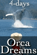
Vancouver Island
Spirit of the West Adventures: We offer sea kayaking tours to the Johnstone Strait & the largest pods of killer whales on the BC coast – Desolation Sound, Quadra Island, & Campbell River - & guided excursions to explore ancient native villages. Set a course for a one of a kind wilderness... more